Digitalt kartarkiv för Kat Orekhova
|
Logga in
Alla användare
|
Språk:
Svenska
Česky
Dansk
Deutsch
Eesti
English
Español
Français
Italiano
Magyar
Norsk
Polski
Português
Русский
Svenska
Türkçe
Український
|
DOMA 3.0.9
Tillbaka
<< WCOC Local Event (2009-11-01)
|
New Haven Training Weekend - Day 2 (2011-03-27) >>
Training, WCOC local event (2009-11-23)
Kategori:
Training
Karta/område:
Wooster Mt
Arrangör:
WCOC
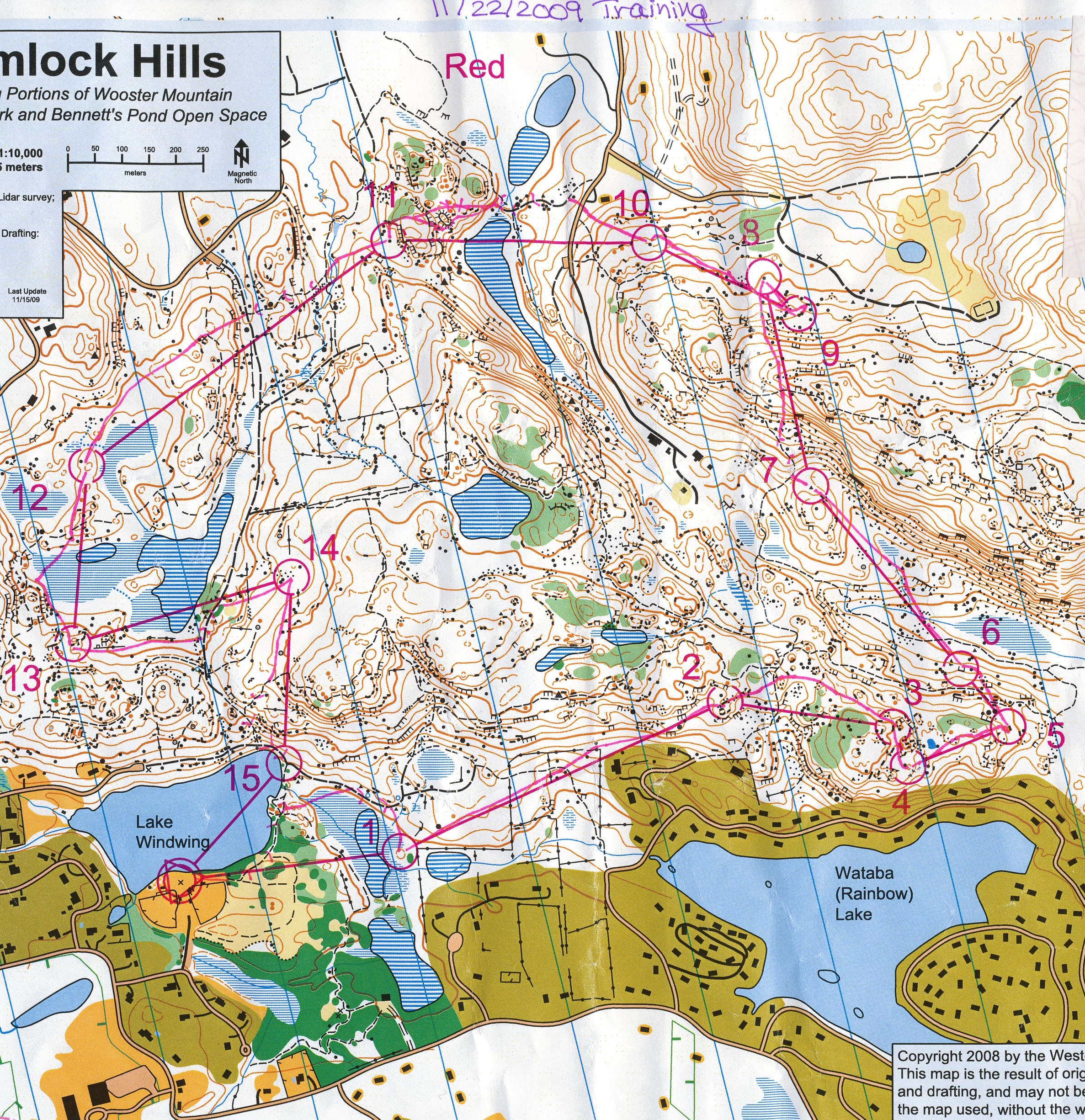
Course Review:
Start-1: Cut off the corner too soon (marsh was very wet), control was obvious once I left the big trail
1-2: was in contact the whole way - perfect
2-3: went left to avoid green, but then was confused by the features (didn't look exactly like what I'd thought), so I went in the general right direction and eventually figured things out. Not good.
3-4: downhill leg, saw the hill with the rock next to it and ran right to it
4-5: hill was greener and rockier than expected - control seemed a long way down
5-6: passed the big rocks, then tried to go down the slope on a compass bearing, but was too scared of blindly following the compass, so I proceeded downhill slowly (knowing I was right of the line), and then matched up a cliff and a rock and went to the control. Diagonal legs across a slope are hard, but even harder when it's so rocky and slippery
6-7: perfect, kept in contact the whole way, planned route to #8
7-8: had planned on going around to the left on the trail, but the hill didn't look too bad, so I decided to climb it. But it was really steep and slow going up, and then really steep and slow going down. I should have stuck to my original plan.
8-9: went straight, past the twin rocks, but then instead of seeing two rocks, I just saw one big one, and it didn't seem to be resting on a contour line either, so I went back a bit to see if I had somehow gone too far, and then looked back and saw the control. (The map is a bit weird there! Definitely only one rock that should be mapped.)
9-10: I went through the stony wide reentrant, and then just to the right of a steep contour with some rocks, but then I felt unsure of my location (things didn't quite look as I'd expected) so I went on a general bearing and tried to match things up until I could see the big rock northeast of the control. It was straightforward from there.
10-11: Saw the two obvious route choices, and decided to go around to the left (along the marsh, then up the reentrant), but it was pretty steep, crappy running along the edge in the beginning (not what it looks like from the map), so I changed my mind and went straight up instead. It was really steep and really slow, and then it was really slow going through the green (which had expanded over more of the hilltop than is shown), and really slow climbing down. At least the control was right there.
11-12: Took the trail, crossed the big trail, climbed up the hill, then went on a general bearing (wasn't reading every up and down) and was surprised to see the reentrant coming in from the right. Immediately corrected, and identified the hilltop north of the control easily. Getting tired.
12-13. Decided to go straight through the marsh, but it was really wet and rocky, so I rock-skipped to the side and almost wound up going the wrong way because I hadn't been looking at my compass (too busy trying not to fall). After that, it was fine.
13-14: Perfect.
14-15: Decided to go straight, but then decided trail would be faster. This was true, but I should have chosen this route right from the beginning.
Visa kommentarer
Dölj kommentarer
(
0
)
Lägg till kommentar
Namn:
E-post:
Spara
 Svenska
 Česky
Česky Dansk
Dansk Deutsch
 Eesti
Eesti English
 Español
 Français
 Italiano
 Magyar
 Norsk
Norsk Polski
 Português
 Русский
 Türkçe
 Український